Monday, June 25, 2012

Riding everything

I have seen a recent article (Road Bike Action magazine) on gravel bikes. Riding on mostly gravel surface roads for long distances seems to be a discipline with growing popularity. Looking around a few blogs, it seems that people use all kinds of bikes, from 26"wheel fat tire mountain bikes to cyclocross bikes.

Although I am not aware of any long stretches of gravel roads around here, the possibility to connect jeep roads, old logging roads, singletrack and paved roads for a whole day, long distance rides, always seemed to me like the best type of riding. It sure is lots of fun to hammer on a super lightweight road bike, or to bomb down technical singletrack (like on this ride a few weeks ago), and no single bicycle can possibly fit the range of applications. But my titanium 29er hardtail is a super capable bike, it can be a race bike (I rode it for an 8-hour endurance race), a commuter bike (I logged about 1200 miles commuting on it to work in 2011), and everything in between bike.

Last Saturday turned to be a perfect day for such an "everything" ride. Sunny, little breezy, fantastic visibility. I have quickly planned the route in my head using many places I have ridden previously, just not in this particular order. So here are just a few snapshots of what may one see on a ride like this:

Started out of Russian Ridge parking lot, pavement on Alpine Rd through Portola Redwoods SP onto Old Haul road, an old redwoods logging road towards Memorial Park and Pescadero.

Claude Monet would be envious of this poppy field on Cloverdale Road near Pescadero.
 Off Cloverdale onto a dirt doubletrack, Butano Ridge trail, towards Big Basin Redwoods SP.
And Howard Hughes would probably like these puffy clouds when filming his WWI air battle movie.
 Green darkness of redwoods alternates with exposed, warm and sandy areas on the Butano ridge trail.

Looking over my shoulder while climbing up to Big Basin confirms the big pond is still there, no fog whatsoever.

Out of Big Basin redwoods, one has to ride on a little used broken pavement road (China Grade), then park access road (CA 236) and finally 6 miles of climbing on state highway 9. Reaching Saratoga gap, as usual with no food and water, relying on the hot dog cart. It has saved me from bonking on several occasions, although ordering a hot dog here in late afternoon always makes me think about E. coli doubling rates at certain temperatures....


Finishing the ride on familiar mix of sweet singletrack and doubletracks along the Skyline ridge.

And a late afternoon long distance view of Mt. Umunhum from the White Oaks trail in Montebello.

Six hours, sixty miles, sixty eight hundred feet of vertical, twelve different nature parks. Priceless. Garmin track here.

Friday, June 22, 2012

No Bikes on Trail!

I often think about what causes user conflicts on trails in the USA. It is sure a very complex problem, perhaps people hate each other for the same reasons as avoiding eye contacts, driving alone in cars, fencing off their homes and pretending to have fun at parties with people they never saw before and will never see again?
Just as a visual comparison, the trails around Riva del Garda were shared happily among hikers, mountain bikers, even electric mountain bike riders!
Here in the SF Bay Area, we often brag about how good the weather is, allowing us to ride year around, and how many trails there are to ride. Sure, that's mostly true, yet the contrasts, such as all Marin singletracks being off limits to bikes vs. the "bicycles must stay on singletrack" signs in the fee for use Tamarancho camp in Fairfax, are stark.
The San Mateo county where I live is notoriously known for banning bikes from their trails (e.g. dirt path along Canada Rd., Huddart and Wunderlich parks etc.). The adjacent Palo Alto seems like a bike friendly town, yet the trail system between Stanford University and Arastadero preserve (both allow biking) and the Skyline highway is closed to bikes. I am talking about the Foothills park (managed by Palo Alto) and the Los Trancos preserve (MROSD). These trails are actually part of the Bay to Ridge Trail a 16 mile hiking trail.
While I rode the Montebello preserve trails and the adjacent Steven's Canyon, Skyline Ridge and Russian Ridge trails many times, I never looked at the Los Trancos trails across Page Mill Road.


This week, being somewhat tired after a road ride and wanting to explore these trails, I drove to the trail head.  Another reason for driving here was the fact that the marine layer fog and clouds were hanging over the ridge just north of here and I was looking for a warm place to run.


I have ran the following loop on these trails: Lost Creek loop (counter clockwise) to Page Mill trail, to Los Trancos Tr. (also counter clockwise) to Steep Hollow - so far all mostly downhill-  and back onto the  northern segment of Los Trancos trail, now climbing back up to Page Mill tr., Lost Creek and to the parking lot. Nice trails! The scenery changed from golden grass, chaparral, oaks, to dense vegetation where the trail forms a tunnel in the brush, to shady woods along the creek, with fern and moss around. There were some nice new for me views and the whole trail run was very challenging, technical and steep. 12.2 miles took me almost 2.5 hours.
So this was the "alternative" mode of trail exploration, and despite the limited range of distance when you use your feet instead of wheels, I really enjoyed the area and the fact that I seemed to have the whole place for myself. Wait a sec, what did I start this post with? No, I really missed mountain bikers flying by me at 25 mph!

Technology Bits from Garda Sympatex MTB Festival

As I flipped through some of my pictures from the April trip to Italy and the Garda Sympatex MTB festival expo, I realized there were a few pieces of bike technology which I wanted to share with whomever would navigate onto these pages.


The festival expo was wedged into a busy Riva street and the big white tent at the race finish, making for pretty crowded two isles of booths. You were better off locking your bike to some post or fence and walking through the expo crowds.


A German component maker Tune showed lightweight and colorful hubs and cranks, as well as an ultra light carbon shell saddle, which those guys swore was the most comfortable saddle for marathon events. I should have bought that one for the trans-California trip!


Trek had a few Gary Fisher bikes on display, now of course disguised as Treks. The Sawyer steel retro 29er bike is beautiful and I am sure that besides daily commuting duties, it could handle the rigors of bike touring, although it does not seem to have rack attachments (there are fender eyelets).


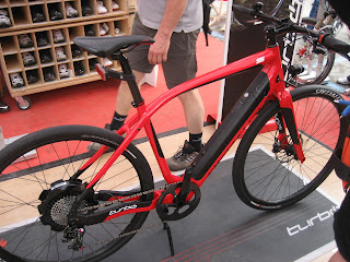
While I am not a huge fan of electric bicycles, this Specialized Turbo eBike surely caught my eye. The design is beautiful, including the down tube mounted battery pack and the hub motor. Just the Elektrak tires alone made me salivate! I could use those on my 29er as a winter commuter tire. They were prototypes, as was the bike, but hopefully one day they will be available (the bike probably won't, at least in the USA, read the Bike Radar article linked above).

Monday, June 11, 2012

Tamarancho rocks!

Since the Hammerstein 8hr race on Saturday took most of my time, I had barely had any time to respond to my friend Martin's ride invitation. When Martin asked "where to?" I just sort of randomly picked Tamarancho. This trail system has been on my radar for a while but I never went. I thought it might be about half way between San Carlos and Vacaville, so about the same driving distance for both of us. I also said OK to a 9AM start. On Sunday, I woke up pretty tired and not feeling recovered at all. But how could I call off a ride with a friend (Martin and I met last year at the British Columbia Bike Race) on a gorgeous day? Quick purchase of trail permits online, short drive to Fairfax, easy ride through the busy downtown streets and there we were.


Now, Tamarancho trails map shows a relatively short, about 10 mile loop. The map is quite schematic and does not indicate any elevation, but all trails are marked as switchbacks. This proved to be more than true: there is no straight trail here, and BICYCLES MUST STAY ON SINGLETRACK signs are at multiple locations. The trails are a great mix of rooty, rocky (sometimes very rocky) and smooth forest tracks. If the trail surface was damp, I would have sworn we were in BC!


It is obvious that these trails are well maintained, and with exception of few sections of brake bumps, were in great shape, despite the popularity of the place. Although on a Sunday ride, we have encountered perhaps fewer than ten riders. Several wooden and log bridges made the ride even more fun.


There was a lot of climbing and the 12 miles or so felt like a whole BCBR stage to my sore legs. A post ride lunch and beer at M&G burgers made a perfect conclusion to this ad hoc ride meeting.

Sunday, June 10, 2012

Hammerstein 8 Hour Race

So feeling pretty good after the much needed recovery post the road tour, I went back to my older post to see if any races were happening soon. On Wednesday last week, I realized there was the new Hammerstein 8/24 race on Saturday June 9 and the registration was closing in a day. I signed up then went to research what race this was.
I rode my mountain bike for more than 8 hours before, even in a race, but never doing laps on one course. My preparation for the race consisted of making sure I had some spare 29er tubes, making eight PBJ sandwiches and buying a big jug of Gatorade. I left for Salinas and Monterey on Saturday morning, the race started at noon. I have never been to the famous racetrack at Laguna Seca before, this is where the Sea Otter takes place every year. Equipped with a brand new GPS, I arrived to the venue 30 minutes before the registration tent closed, but with an hour and half to get ready.  I have set up my very modest, solo racer pit, surrounded by sophisticated camp sites of racers doing the 24hr race, their teammates and crews.


The lap distance was 10.7 miles, so I went out with one bottle of drink per lap. The first lap felt great, I thought, boy, this is going to be just a long bike ride. The course was a nice mix of fire roads and sweet singletrack, winding through a poison oak jungle. There were a few sand traps, but overall nothing too technical. The lap took me about 70 minutes, I switched the bottle and ate one PBJS, thinking OK, six, seven times more? On the second lap I tried to do the math, knowing that my brain would probably make a mistake as the fatigue would set in later. I figured six laps with no mechanicals should be about 7 hours. So I took it quite easy, visiting my pit after each lap to grab a fresh bottle and progressively less fresh peanut butter and jelly sandwich. These stops added to about 25 minutes of delays, so before the 6th lap, I just filled the bottle and grabbed a gel and finished around 7:25PM.
Overall, I had fun, liked to ride with others, I liked the course, it was an ideal track for a 29er hard tail. What I could not comprehend was how could somebody ride for another 16 hours after I went home. Those solo 24hr racers are alien species to me.
The results are not posted yet officially, so here is an unofficial evidence, the elevation profile of the 65mi/8900ft vertical ride, from the Garmin page:

June 13 update: results are posted on the GBE web page, my time of 7 hrs 23 min 14 sec has earned me fifth place out of 13 competitors in the 8hr solo men 50-59 category.

Friday, June 1, 2012

Sierra Bike Tour GPS Tracks

Almost a week has gone by since my return from my inaugural road bike tour. This trip was the longest in mileage and the most strenuous in climbing of all my pedal powered endeavors so far. Besides taking care of all kinds of backlog items this week, I feel tired, hungry and cold, so I eat, sleep and enjoy the warm weather we have this week.
So as the final wrap-up, I am posting links to the Garmin tracks here:

Day 1: Chula Vista to Julien
Day 2: Julien to Yucaipa
Day 3: Yucaipa to Crestline
Day 4: Crestline to Palmdale
Day 5: Palmdale to Tehachapi
Day 6: Tehachapi to Lake Isabella
Day 7: Lake Isabella to Three Rivers
Day 8: Fish Camp to Lee Vining

And finally, here is a Google Earth view of the whole route. 750 miles (probably close to 1000 miles for John with his two additional stages) is about one third of the whole ACA Sierra Cascades route, so this one is not finished and I hope to pick up the route one day at Lee Vining, for a ride further up north.