Monday, September 26, 2011

Euro Cycling Bits

On a recent trip to Europe, I visited three places which all had something to do with bicycling, despite the fact that my time there was completely off the bike.

Stop One: Prague, Czech Republic. Clearly, the "Lance effect" of the new XC World champion Jaroslav Kulhavy aka "Kulhec" is huge. The August World Cup XC race in Nove Mesto na Morave attended 30,000 spectators (according to the Czech cycling magazine Peloton.cz ) and 250,000 people watched it on TV! That's as if 600,000 people came to see a MTB race in the USA (based on country populations). And of course, another Czech Michal Prokop is again (for the third time) a World champion in 4-cross and few other Czech female and male racers placed among top ten.

I saw many people riding bikes around Prague, mostly hardtail mountain bikes fitted with racks, lights and fenders. The city bikes seem to be absent, but a creative use of bikes for advertising is definitely not:


Stop Two: Paris, France. Nothing cycling- worthy here, except the fact that I rode in a taxi by the place where the Tour de France finishes every year:


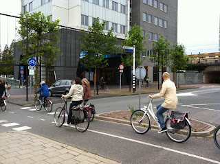
Stop Three: Leiden, The Netherlands. Very nice university town with the standard Dutch biking culture. Dedicated bike lanes with their own traffic lights, everybody riding in their street clothes, no helmets, talking to each other, talking to their cell phones etc. 


All Dutch street bikes are pretty much the same and there are so many of them everywhere. The bike parking and storage does not seem to be an issue:


And surprisingly, for a small country and a historical town with narrow streets and sidewalks, bikes and bike racks occupy a dominant space, literally and figuratively speaking:


We live in one of the most cycling friendly places in the USA, the Bay Area weather allows us to ride all year long, most people can afford really nice bikes, yet the car society tradition continues and the best American MTB athletes do not place above the 20th rank in the UCI events. As with so many other things, mountain biking was invented here but perfected elsewhere.

Thursday, September 15, 2011

Mini Tour de Peninsula on 9/11

The great thing about mountain biking in the Bay Area is that there are lots of other people seeking new routes and trying to push the limits. They also share their routes online or organize low key events, such as this 2010 MTB Tour de Peninsula. I have been itching to try to ride the route, but have been always turned off by the distance (80 mile+) and the fact that there were long road sections.
On Sunday, September 11, I have decided to try a shorter (lots shorter!) version of the ride, starting at the Windy Hill OSP parking lot.
The day did not start too well, I broke my favorite Garmin Edge 500 GPS, don't ask how. So here is a "manual" ride recap:
1. Spring Ridge Tr up to Skyline: steep, sunny, hot, 30 min climb.
2. Skyline (road) to Ripley Ranch Rd.
3. Ridge Tr to Hawk Tr: windy, cold, rain clouds rolling in, a few drops of rain.
4. Hawk Tr: great views from this narrow ribbon of singletrack
5. Ancient Oaks Tr to Bay Area Ridge Tr
6. Cross Skyline just north of the vista point
7. Clouds Rest Tr, Meadow Tr to Alpine Tr
8. Alpine Tr to Page Mill Rd, cross the road to the new White Oaks Tr
9. White Oaks Tr: this newly cut trail is much better than the old rutted trail!
10. Skid Road Tr to Skyline, cross Skyline, across the parking lot
11. Sunny Jim Tr to Horseshoe Pond
12. Tree Farm Tr
13. Chestnut Tr
14. BART
15. Peter's Creek Tr
16. Ward Rd intersection to Hickory Oaks Tr
17. Across Skyline onto Saratoga Gap Tr
18. Saratoga Gap: hot dog, water, found a slow leak in rear tire and decided to ride on it after 100 pump strokes
19. Retrack to Peter's Creek Tr and across Skyline to Grizzly Flat Tr, pump up
20. Steven's Canyon Tr uphill
21. Steven's Nature Tr to White Oak Tr
22. Cross Page Mill Rd onto Alpine Tr, pump up
23. Alpine trail to Alpine Rd
24. Ridge Tr connector back to Windy Hill parking lot
25. 64.7km = 40.2 miles, 5 hours moving time, 6 hrs total.

Compare the blue 80+ mi MTB TdP route with mine in red, so it looks like I need 12 hours and lots more training to ever try the full route.


Thursday, September 1, 2011

GPS Frustration

I think the Garmin Edge 500 I use is the greatest component on my bikes. No sensors, no wires, no wheel magnets, no wheel size calibrations. I like the fact that you can move a single bike computer among several bikes. I like it's accuracy and also the fact that it is small. I don't need a map on a small, hard to read display. I like to study maps on paper or online and plan my routes to the point where I remember most important turns. And there is the iPhone, in case one gets lost and is lucky to catch any At&T 3G signal (a rare occasion west of I-280).
So where does my frustration come from? I guess as many others have done, I sometimes forget to stop the Garmin at the end of a ride. This must be the old cycle computer habit. Unlike the magnetic sensor computer, the GPS does not care that your front wheel is not moving, as long as you are moving, or your bike mounted to the roof rack si moving, it keeps acquiring the waypoints.
OK, so I come home, plug the Edge into the Mac and see that my ride now has added 57.3 miles at an average speed of 60mph. Marketa says "Why do you care how many miles, vertical feet, calories etc you recorded? Did you enjoy the ride?" and she is of course totally correct. But I just cannot log such a track! And not logging anything at all for a four hour sweaty hard ride is not an option, either.
So what's the solution? Ideally, I can imagine a graphical editor which could actually open Garmin's tcx files directly without exporting them as gpx (that's dreaming now) and lets you erase route points, split tracks etc. and save the output file. Sounds simple enough to me. Here is what I tried so far:

GPS Babel: nice interface, the GUI has all the right options and buttons (some mean nothing to me), worked in splitting a two ride track into two. But would not truncate a track neither by time, nor distance, no matter what I tried. If the conversion was reported successful, then there was no track after uploading the data back to Garmin Connect.

Breadcrumbs: an online tool, looks like my GPS dream come true! After the mandatory registration, I tried and bummer, the maximum file size for uploading is 2MB....  all my gpx files are bigger than 2Mb. Otherwise, I think this is the way to go.

So I am now back to the Mac's TextEdit, which I tried before to edit XML file but ran into trouble (this is really easy on a Windows machine!). Turns out, you have to apparently change several editor settings described here. My method is to open the exported gpx file in an xml editor, find my ride end either by zero speed (could be tricky if you make frequent stops) or location (by matching to the ride start), deleting the extra block of trackpoints and changing the start time by 1 second to fool the Garmin upload to make it think this is a new track.
My next GPS experiment was going to be trying to follow a previously recorded route on the Edge 500, but I am not really sure if it is worth the frustration...