Sunday, January 26, 2014

Thank you, California, for The Triple R!

Or, as I found online, "Ridiculously Resilient Ridge" of high pressure. While the RRR is causing a real trouble in California (nobody who reads Steinbeck should be even mildly surprised, though), we are enjoying a dry, sunny and warm weather here in and around Seattle.
Case in point, Saturday January 23rd, 52 degrees Fahrenheit. In the mountains! I drove to Tiger Mountain for a trail run, wearing shorts, but also a long sleeve jersey, a vest, hat and gloves (you know, just in case, it is winter after all). I decided to run trails around East Tiger, this is the side of the 4-summit mountain where we go mountain biking in the summer.

I ran the Iverson Railroad trail to the TMT, a mild climb for about 3-4 miles. Then I came out of the woods into a logged clearing and here, the sun hit me with full force. In a short time, I felt like a chicken on a grill.
Luckily, I soon entered a cooler forest, but the trail, instead of being spongy and wet, was very dry and needles and small branches made cracking sounds under the soles of my Hokas. Very weird. I got lost a little bit and by mistake plunged down Hobart Grade to a treacherous creek crossing and realized I was scrambling up a wrong mountain about half mile later. Back to the intersection, I wondered how could I have possibly missed the TMT sign, since it was about 3x3" big, made of wood perfectly matching the tree it was bolted to and about 7 feet up above the trail. The 15 mile Railroad trail eventually connected to the East Tiger trail, which was absolutely wonderful. When East Tiger intersected Preston Railroad, I was in a familiar territory. This is the famous downhill we all like to bomb down on mountain bikes. The trail was all downhill, but I did not realize how difficult the footing would be on a technical bike trail. Downhill but no rest.

Nice trail work Evergreen Mountain Bike Alliance! I got to sign up for one of the trail work parties, shame on me I haven't done it yet.
When the trail comes out on a fire road, you think you are almost done, but there are about 4-5 miles more from this point, first on seemingly endless fire road, but then, as a great way to the finish, the Northwest Timber Trail singletrack.
Total run time: 3 hours 35 minutes
Mileage: unknown, long enough to hurt
Elevation gain: also unknown, also hurt pretty bad
Number of people seen on trails: 2
Joy factor: high

The warm weather did not quite last through Sunday, there was lots of fog in the morning and it is quite amazing how fog makes the air feel so much colder. I took the 29er on Grand Ridge trails for my favorite lollipop ride - Grand Ridge, a loop around the Duthie Park using the "XC" rated trails and back on Grand Ridge. Lots of climbing, but the flowy trail and nice woods around compensated for my sore legs on this almost 4 hour ride. High today "only" 47F.

I wonder if people in Seattle will actually start wishing for more rain! What's the world coming to?


Monday, January 20, 2014

Winthrop Fat Bike Gathering

Since I bought fat Pepper last fall, all my fat tire rides were solo. Of course, there are always people stopping and asking how hard is it to roll on monster tires etc. I did not meet any other fat cyclists on winter trails, heck, I did not meet any riders, even the skinny ones! An email to a fellow Meetup mountain biker connected me to another rider, whose friend video documented a 2013 fat bike gathering at Ocean Shores, somebody sends a Northwest Fatbike Facebook link, and all of a sudden there is a community of fat tire enthusiasts, meeting on the MLK weekend at Winthrop, WA. The meetup was hosted by the Methow Valley sport trail association (MVSTA) and the local ski / bike shop, Methow Cycle & Sport. OK, so now you have all the links, happy browsing.

Winthrop is a cute Western town on Highway 20, north of Twisp and south of Mazama. Highway 20 over the Washington Pass is closed in the winter and buried under tens of feet of snow and avalanche debris. This makes these towns to be "end of the road" destinations. Local atmosphere is very friendly and you can get $1 espresso in coffee shops and fantastic fresh baked goods and sandwiches in delis.

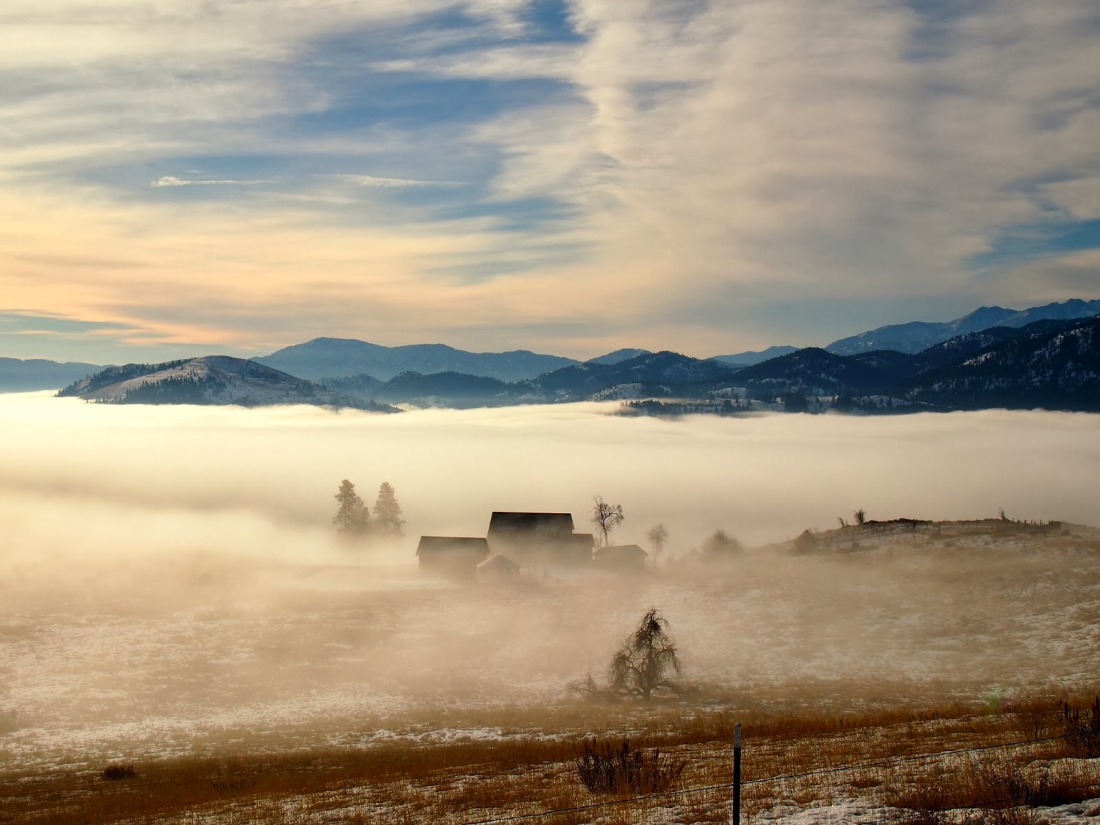
On Saturday morning, a group of about twenty people meets at the bike shop, and after some introductions and trail information, we all head up Gunn Ranch road to a trailhead. The valley fog layer ends right about at the trail level and the views open up.

This is a social ride, lots of talking, picture taking, stopping and regrouping, even some flat flasks are being passed around. We ride through woods with occasional views of the surrounding mountains, on a very hard packed snow surface. An ideal day for fat bikes, cross country skiers would be miserable on these trails.

We climb up to Grizzly Hut for a snack and group photos, under blue skies and at an almost balmy temperature of 38F.

The downhill part is very fun, you can tell the locals know the trails and have the technique to let their bikes fly downhill. There is more stopping for pictures and videos and views.

After lunch in town, the organized event becomes somewhat disorganized, but a group of riders heads up to Paterson Lake, which is completely frozen over.

After a little bit of trail scouting, everybody decides to ride a loop around the lake. I feel like a climb would do me good after a slice of pizza, so I head up Sun Mountain towards the lodge. The trail here is a steep singletrack, basically a foot wide sliver of ice and snow on a grassy prairie hill. As I reach a horse corral near the resort, my hopes of climbing above the fog layer do not materialize and I head back down to the lake on more technical narrow trails. As it gets later in the afternoon, the fog layer above the frozen lake thickens and I hammer on the flat lake trail loop, with about 50 meters of visibility in a pink haze.


On Sunday morning, I meet with Mark, a young mountain biker and snow biking enthusiasts from Missoula, MT, who has been exploring local fat bike routes for a few days. He rode some big rides up to high altitudes, but I convince him to ride the Highway 20, thinking it might be an easy ride before I head back to Seattle. At the road gate, we see bunch of backcountry skiers who use snowmobiles to access skin tracks up those crazy couloirs and chutes around the pass.

We begin our ascent on a nicely packed snowmobile track, the valley is in shade and the morning air is freezing, but there is much less fog in the valley and none up here. Few miles up, the snow, churned up by the snow machine belts, has a consistency of crystal sugar and keeping a straight line becomes a bit more difficult. We let some air out the tires and keep pushing on.


After gaining some more elevation, the snow turns into powder, walking on it becomes impossible without punching deep holes. We again decrease our tire pressure to the point where I think I can squeeze the rubber all the way to the rim, but low tire pressure is key to maintain flotation on snow and be able to ride. We ride, sweat and our conversation stops. We see a huge switch back of the road, after which the highway climbs up along a very avalanchy looking slope. We decide to try for the bend, and after what seems like a long and painful effort, we get there.

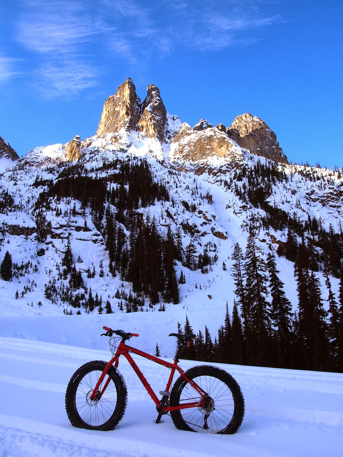
From here, we can see the whole valley below and also some jagged rock walls above us. The valley road is now sunny, but we are still in a shadow cast by the spires to our left. About a half mile up, we see the shadow edge and it is sunny above that point. At this point, I am willing to push the pedals another stretch just to reach the sunny spot.


This section of the road has very soft, deep powder, just somewhat packed by a group of snowmobile riders who break trail ahead of us. Under "normal" winter conditions, this would be a very dangerous part, we ride over steep ridges of snow and dip down steep snow banks, formed by snow slides from the chutes to our left. I can definitely feel the altitude here, but here is the Washington Pass sign, and the road turns steeply downward.


We hang around a bit, enviously looking at ski tracks up in snow filled bowls, but also looking forward to the descent. We start to glide down the mountain and the remaining 3 psi or so in the tires act as natural brakes, so we very comfortably cruise down at about 10-13mph. The best thing is to let the bike find its own best path, too much steering feels like a recipe for a wreck. We have to pedal some more on the final mile and half, out of the sun and on a flat trail, now definitely feeling the lack of muscle glycogen. Really, there is no better way to get stronger on a bike than fat biking.
Before my long drive home, I replenish my glycogen at the Mazama store with the aid of a mixed berry bread pudding with whipped cream and lots of coffee.
This was a really enjoyable weekend spent among people who love this part of the state, the trails and all the sports you can do here, without a trace of any judgment for other area users. They all seem to run, bike, ski and ride the trails and were very happy to show us their slice of heaven.

Sunday, January 12, 2014

Careful What You Wish For

At the end of 2013, record low temperatures were recorded in Seattle and around. Everybody complained about how dry December was, how terrible there was no snow at ski resorts etc. I actually liked the dry weather a lot, cold and dry, I don't mind. One can go running any time and forest trails were in great shape for mountain biking. Thin cover of ice and some snow was good for fat biking.
Then, weather gods, sick of hearing the whining, flipped the switch: a week of heavy rains, strong winds, even lightning and thunder! Three feet of fresh snow in three days at Stevens Pass. Such epic snow conditions dictated setting the alarm clock at 5:30 and hitting the road at 6:30, thinking "I will be there at least an hour before everybody else." Brilliant idea, Jan, the whole greater Seattle area thought the same. First hopeless traffic jam already in Monroe on Highway 2. I stopped for gas and a restroom break, only to find the highway free of cars! Where was everybody? Eight miles before the Stevens summit, I found them all:

After 65 miles driven in 4 hours, the summit parking lots were hopelessly full. While everybody was trying to park at an RV lot, I pulled ahead and saw a sign saying "Overflow parking 1 mile".  As I approached the overflow lot, the car ahead of me was the last to fit in. No need to despair, another over-overflow lot was 4 miles down the road, actually this was the Stevens Nordic lot where we skied and fat biked on Christmas Eve. This time, I am lucky and I am the last car allowed in. We are shuttled back to the mountain and I buy my lift ticket at 12 noon.
Now, skiing was really epic, 2 feet of powder at the top allowed for falling down chutes, landing in soft cushions of snow, lots of untracked powder among the trees, simply white bliss. Ans it kept coming down in heavy doses.

My goggles were as fogged up as my phone.
OK, so the short version of this post so far could have been: I went skiing and got stuck in traffic. Big deal, thousands of other people experienced the same. My original idea for this post was to compare two modes of moving on snow. The first one was downhill skiing. I skied over three hours non-stop, legs burning, sweating and gasping for breath. I made about 15 runs, each time being mechanically transported about 1000 vertical feet. On the way down, I covered terrain I could not even contemplate moving over any other way. Not on snowshoes (too steep), not on foot (too deep snow), not on a bike (duh). My wide skis just flew through deep snow, I can fit tight turns among trees, jump down some small rock outcroppings. All this at speed over 20mph.
Now to the second part: the parking lot where I left my car is connected to the back side of Stevens with a fire road, used by the Nordic center. It is about 4 miles, with a gentle slope down the Mill Creek valley, but it is out of bounds. I figured that I could ski longer, let the shuttles leave, and as the back side lifts stopped running after 3PM, I would drop down the back side, pick up the fire road and skate the 4 miles. As I left the busy ski resort behind, I found myself in a quiet cathedral of tall, snow covered trees.

I was able to glide down the first half mile or so, then the road flattened and hard work began. I can cross country ski classic style and I also know the basics of skating, so the technique was not a problem. The problem soon started to be my leg strength, skating with 10 pounds of boot, binding and wide ski on each leg in 5 inches of fresh snow. Soon, my legs started to protest and burn. But there really was no other means of how to move forward, other than shouldering my skis and walking in boots not made for walking more than 100 meters. And so I skated more, swore and sweated. Fours miles, net downhill, at 33F temperature (it poured rain below 4000 ft) and I was pretty toast when I got to the car 45 minutes later. Excellent workout, but it just showed that for snow sports, having the right gear is a must. Since I already spent money on a fat bike (no regrets!), a backcountry ski setup will have to wait another season.

Sunday, January 5, 2014

Jungle Games and the Search for Snow

The dirty tricks weather gods have been playing with us this winter (cold but very, very dry) have actually a few advantages: it is not pissing rain, which I hate, mountain biking trails are in great shape, and fire roads in the mountains are covered with 3 inches of frozen snow instead of 3 feet of powder. So while the freshly tuned skis sadly lean against the garage wall, opportunities for biking abound.
A strong group of six riders got together Saturday at Tolt Macdonald park. This is my favorite place, a small area with countless singletrack trails, technical riding and the only color you see there is green of all shades. That place is a rainforest jungle. After the morning fog in the river valley burned off, it was a great sunny day.
Since each trail intersection has between two and five possible trails to take, we decided to play a game of leap-frogging: the rider in the front of the pack will pull aside at a trail intersection and lets the second rider pick one trail, quickly, without planning. Then the first rides falls all the way back. This repeats at each trail junction. After four hours of playing this game, we almost got it mastered, but by then, most of us were toast. The trails here, with wet roots and roller coaster profile require one to stay in tall gear and power through, tight turns have to be leaned steeply, and this much body English is quite tiresome. It is also very difficult to take pictures at Tolt, on an overcast day, one needs a very fast lens in the green darkness, on a sunny day like this, the high contrast between shade and sun rays is challenging for digital photography. Luckily, Marc took a few pictures, so I can share one.

Photo: Marc, Rider: Thomas
Sunday was a blue carbon copy of Saturday and I planned to ride the fat Pepper up Highway 410, closed in winter, from the gate at Silver Springs up inside Mount Rainier NP towards Sunrise visitor center. This is a popular XC ski route under normal conditions, but today the surface was anything but normal. The highway surface was a mix of bare asphalt and ice, with more ice as I climbed up. At one point, the road turned and I found myself sliding from one edge to the other, down the camber, no matter how much I counter-steered. This will be fun going down, I thought, but quickly forgot about the ice at the intersection with Sunrise Park Road, which had a good snow cover and was packed by trucks and snowmobiles.

The next 4-5 miles were super enjoyable, except it was cold in the White River valley and the slant winter sun reached it only at few spots. Warmed up by the climb, I removed my Hestra gloves and unzipped all layers, just to stop a few minutes later to put the gloves back on, add a balaclava and to close all zippers.

No bike stand needed
I soon reached the junction with Sunrise Park road, which climbs steeply the northern slope of the valley. I found the road completely untracked, started my uphill climb, only to get stopped abruptly by my rear wheel crushing the icy crust and sinking about a rim deep. The sides of crust now grabbed the tire, making it really difficult to ride. I let lots of air out from both tires, got in the saddle again and leaned on the handlebar while pedaling standing to lighten the rear wheel. This worked fine for about fifty yards, until my front wheel dug through, almost making me fly over the bars (uphill!). So I returned to the junction and took the road towards the White River Camp, which had multiple snow machine tracks. Here, I had to shift the granny gear to keep moving, thinking about how hard it is ridin' them fat bikes on snow.

At the camp, I had the whole picnic area for myself (actually, I did not see a soul on this 20+ mile ride). My effort was also rewarded by a decent view of the big hill, but frankly, the best views of Mt. Rainier were during the morning drive, just past the Muckleshoot Indian reservation. I guess when you climb a mountain, you rarely see it.

After two Clif bars and a whole chocolate bar (!), the downhill was fun - in a packed track, the speed increased scarily, but slicing the crust kept the speed in check. I did not realize how steep this road was! With much less pedaling effort, I started to get cold, until I reached the ice rink on Hwy 410. Here, mostly sliding with one foot down to feel the road surface, I almost crashed several times, took a few good pedal pins into the shins, but this ice rodeo kept my adrenalin levels high enough to forget about the cold.
Back at the Sno-park, it took a full thermos of sweet chai to defrost. I am bringing this hot drink to each of my snow bike rides now.