Do you know that feeling when a deadline approaches, the task lists seem to keep growing instead of shrinking and the time actually keeps speeding up until the clock hands move so fast they are just a blur?
I have been feeling like that over the past two weeks, which in part explains for my inactivity here. After getting just well enough after a weaponized virus attack to be able to complete a scientific paper, explaining how a group of college students could possibly botch such a simple experiment as demonstrating the Stroop effect to no effect at all, I realized I really want to do a few bike rides and runs around the Bay as a way to say goodbye to the area.
Jill came to my rescue and asked to go for a ride, so we pedaled up Mt. Hamilton for the views of the Bay Area which did not happen due to hazy wether, but we got a great view of some of the first season's rain clouds.
Then, two days later, Jill and Beat, being in a recovery mode, signed up for a 50k trail run along the Skyline ridge, and motivated me enough to sign up for a half-marathon distance. I really enjoyed the run, despite two wasp stings in my right calf and a spectacular wipeout when showing off in front of several young and pretty female runners. We all enjoyed a big sushi dinner post race, me not even knowing that I finished third in the old fart category.
The next day of recovery was made very special by a visit of my friend Pavel and his family. Pavel baked a great peach cobbler, which made me forget about a late afternoon flight to San Diego, as well as about my swollen, red and hot right calf. I'm pretty sure that cake fueled me for the whole Monday during a 10-5 job interview. They say interviewing for a job is like dating, but what was the last time you tried to look attractive to somebody for seven hours straight? And all interviewers were guys!
I'm typing this as I wait for my flight home, which I will soon call my second home. But before that, I need to go for another big bike ride
Monday, October 15, 2012

Tuesday, October 2, 2012
Heat induced experiment
With the outside temperature hovering around 100F, the second floor of our otherwise always cool townhouse uninhabitable, my bronchi congested, voice gone and an inflamed middle ear, I went to the garage to look at my bikes. The machines have been sitting idle there for the past three days, and I would take riding in 100 degree heat over being sick any time. Instead, read a few biking magazines and realized that you cannot open any of them without headlines like "the 650B revolution!" or "Death of the twenty-six inch wheels"...etc. screaming at you. I won't go into a debate on what wheel size might be best for mountain bikes, but I will share results of my primitive experiment here (it is really hot out there).
After I installed the 700x35cc slicks on my 29er, I noticed how much smaller the wheels looked. So I decided to measure the size of wheels plus tires on all our bikes. Now, I should be clear here: this is not a well controlled scientific experiment. I measured different wheels (different brands) mounted with different tires. No attempt was made to compare wheel weights or their ability to roll over terrain obstacles. My tires are at various stages of wear, although none worn to the casing, and they were inflated to various pressures.
So here are the four players:
After I installed the 700x35cc slicks on my 29er, I noticed how much smaller the wheels looked. So I decided to measure the size of wheels plus tires on all our bikes. Now, I should be clear here: this is not a well controlled scientific experiment. I measured different wheels (different brands) mounted with different tires. No attempt was made to compare wheel weights or their ability to roll over terrain obstacles. My tires are at various stages of wear, although none worn to the casing, and they were inflated to various pressures.
So here are the four players:
 |
| AMC 26 tubeless/ Nobby Nic 26x2.25 |
 |
| Specialized 29/ Vittoria Randonneur Hyper 700x35cc |
 |
| Neuvation M28/Conti GP4000S 700x23cc |
 |
| Vuelta XRP 29 / Kenda SB8 29x2.0 |
All wheels were propped against a cardboard box in as much upright position as possible and a tape measure was used to mark the wheel diameter. I estimate the measurement accuracy to be about +/- 5mm.
And here is the result:

Edited Tuesday October 9, 2012: Here is a comment from a guy who knows a thing or two about bikes: John Nobile, the 2008 Great Divide Race winner and record time finisher, and an overall genius engineer:
"The added overall diameter of a tire (of a given diameter rim size) should be in direct proportion to the tire width, since the (inner) cross section is typically designed to be nearly round (although the rim width affects the roundness a bit), because the pressure tries to force perfect circularity. Outer diameter is of course also effected by tread thickness, as you mentioned. Car tires can get away with non-circular cross sections only because they are heavily reinforced along the circumference, usually with steel."
So I guess there is no future for bike tires that would be taller than wider, plus such a tire would probably ride like sh!t.
A table listing all possible rim / tire sizes is also here: http://www.bikecalc.com/wheel_size_math

Vuelta 29er wheel with a large volume Kenda Small Block Eight ..... 73cm=28.4"
Specialized 29er wheel with a commuter / touring Vittoria 35c tire.... 69cm=27.2"
American Classic 26 tubeless with Schwalbe Nobby Nic ................... 67cm=26.4"
Road rim with Continental 4000S 23c tire ...........................................66.8cm=26.3"
Conclusions: twenty nine inch wheel and mountain tire is not quite 29, presumably because the low tread profile on the SB8. Put a touring or cyclocross tire on a 29 or 700cc rim and you almost get 27.5 (650B). A big knobby tire on a 26-er rim will be more than "just 26". And a large diameter road rim with a skinny tire is pretty much a 26". Could somebody make a fat bike style tire that would fit onto a 26" rim but be a quarter inch taller? It would sure be heavier but I would not have to buy the revolutionary third wheel size and worry about fitting it into my 26" bike farme, or (horror!) buy a 650B new bike! Or how about an on-the-fly expandable tire for tuning your ride to the surface under your wheels while you ride? It is 9PM and 90F in the bedroom and I'm running a fever.
"The added overall diameter of a tire (of a given diameter rim size) should be in direct proportion to the tire width, since the (inner) cross section is typically designed to be nearly round (although the rim width affects the roundness a bit), because the pressure tries to force perfect circularity. Outer diameter is of course also effected by tread thickness, as you mentioned. Car tires can get away with non-circular cross sections only because they are heavily reinforced along the circumference, usually with steel."
So I guess there is no future for bike tires that would be taller than wider, plus such a tire would probably ride like sh!t.
A table listing all possible rim / tire sizes is also here: http://www.bikecalc.com/wheel_size_math
Monday, October 1, 2012
Adapt or die
The above quote by PW Botha has been used and misused by management of probably every single company out there. The truth is, we are humans and it is sometimes tough to change our habits and ways. But if challenged, we do have to adapt or we would not be here much longer. I can personally attest to that. While searching for a new job during the past six months of extended biking and running "vacation", I realized how much the biotech job market changed. So when I was offered a job recently, it was no surprise that the offer came with a few challenges I would have to adapt to. Now, the easy part is that the company researches the human adaptive immune system using genomics, which I love. Being adaptable, I accepted the job and started to explore how easily I will adapt to my future place of work and residence.

Lets say, I would live in an apartment like this one

in a highly walkable neighborhood (walking score 90), two blocks from a bike trail and about 10 miles from work.
I think I would bike commute to work, run errands and do light grocery shopping on my bike. My first concern about adapting to this new environment would be weather. Could I forget about being a California wuss and ride in drizzle or rain? Would I miss the seven months of dry sunny weather?
 And what would be the best wet weather commuter bike? I cannot yet answer the previous two questions, but the bike question is simple. My titanium 29er hardtail with slick 700x35 tires, perhaps equipped with fenders, will be an ideal bike for this purpose.

It took me half an our to adapt the bike to the new role. A test ride on a familiar former route to work proved how much faster the bike has become. So here it is, a knobby tire endurance racer and mixed terrain travel bike, a commuter bike and perhaps even a touring bike to complete the Sierra Cascades tour one day? Perfect.

I know I will miss these views from local trails, but that is just a part of the adaptation process.

Lets say, I would live in an apartment like this one

in a highly walkable neighborhood (walking score 90), two blocks from a bike trail and about 10 miles from work.
I think I would bike commute to work, run errands and do light grocery shopping on my bike. My first concern about adapting to this new environment would be weather. Could I forget about being a California wuss and ride in drizzle or rain? Would I miss the seven months of dry sunny weather?

It took me half an our to adapt the bike to the new role. A test ride on a familiar former route to work proved how much faster the bike has become. So here it is, a knobby tire endurance racer and mixed terrain travel bike, a commuter bike and perhaps even a touring bike to complete the Sierra Cascades tour one day? Perfect.
I know I will miss these views from local trails, but that is just a part of the adaptation process.
Tuesday, September 4, 2012
Kalalau Trail
I had first heard about the Kalalau trail on the island of Kauai, HI in 2003 during our first visit to Kauai. That year, we hiked the first 2 miles of the trail to Hanakapiai beach, as many tourists do, wearing sneakers. It was wet and our sneakers ended up in a garbage can after the hike. But our appetite to hike the 11 mile long trail along Na Pali coast out and back, was whetted.
So we were back a year later, this time equipped with heavy duty hiking gore-tex boots, backpacks, sleeping pads and bags, a tent, stove, dried meals, camelbaks and water filters etc etc.

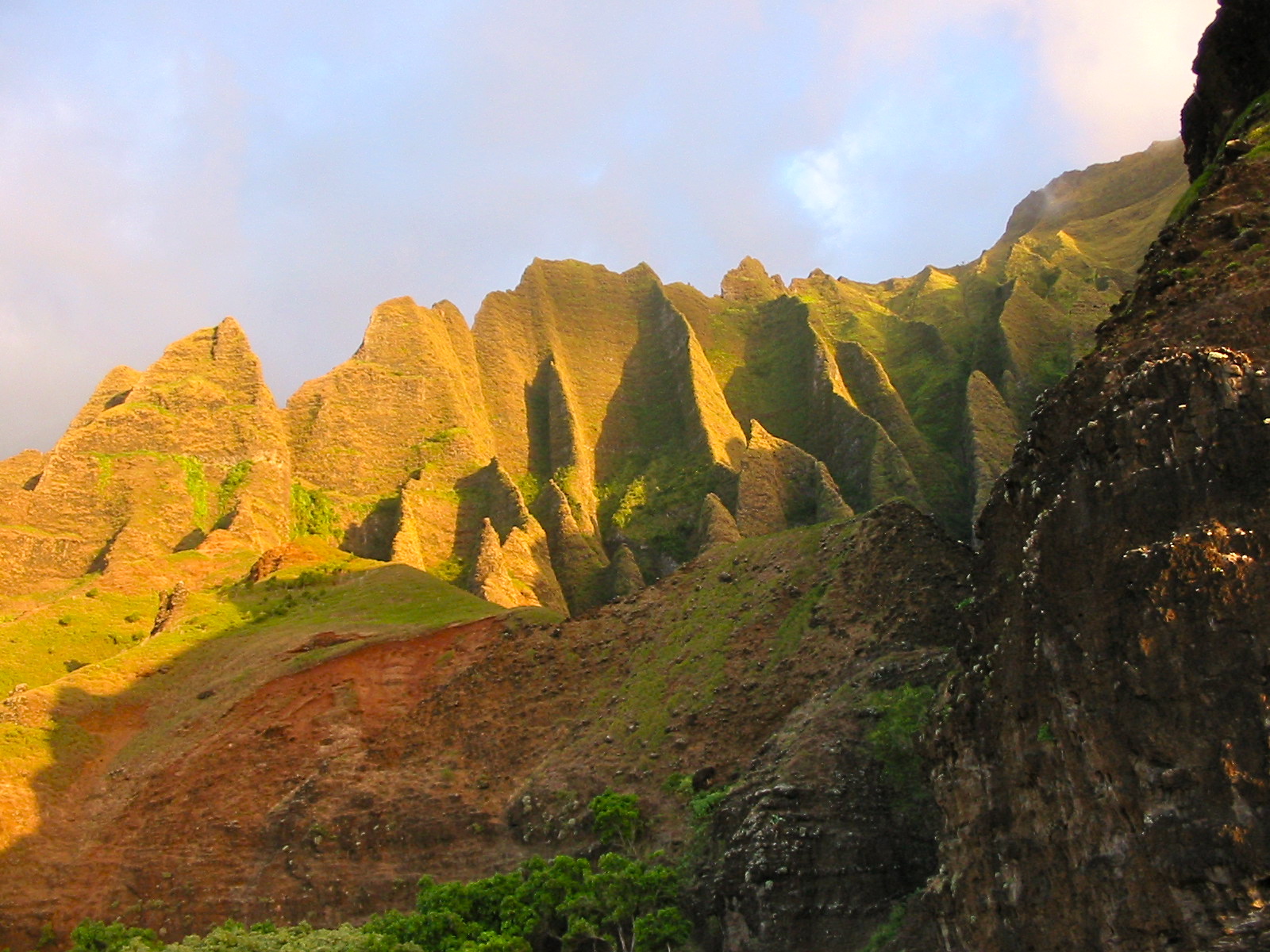
It rained, because it always rains in Kauai, the trail was wet, muddy, slippery, rutted, steep and rocky. It took us eleven hours to reach the Kalalau Beach, so the pace was 1mph. The beach at the trail's end was worth all the effort.


It rained some more on our way back the next day and I remember being pretty desperate about my wet boots, socks and blistered feet. Water got inside my boots not from walking through the mud puddles, but from the top, flowing alongside my legs in rain and every time I dragged my legs through wet vegetation. It was a tough hike. We realized we overpacked a lot and decided that one day, we will be back one day for a fast, minimalist overnight hike.
That day almost happened to be this past weekend. I say almost, because the original plan was quite different: Marketa flew to Kauai to run her third Kauai marathon (and her third this year). But a plane-acquired virus got a hold of her and her taper leisure 5 mile run a week before the marathon weekend ended up in projectile vomiting all over the lush island vegetation. Next, she ended up in bed with a high fever. So I packed all light hiking accessories and went to Kauai hoping that if running a marathon was out of question, the Kalalau trail would be an easier substitute when she got a bit better. By Saturday, it was clear that the virus was a vicious one and plans had to be modified again. We decided on me testing the light hike version and gear by allowing myself about seven hours for the hike and to see how far I would get in 3.5 hours before turning back.
Despite wearing the same T-shirt and shorts as eight years ago (yes, the Patagonia gear is indestructible), I carried a Camelbak with 3 liters, a filter, first aid kit, an emergency headlight, and three power bars. Most importantly, I had put on my trail running Adidas shoes, running socks, and insulated my feet with waterproof gaiters. I also carries spare socks in a ziplock bag as well as thin neoprene socks.
 I started the hike at 7:40 at the newly improved trail head, equipped with maps and many signs with long lists of all activities and behaviors prohibited. The first section of the trail was improved hugely, with water bars etc., but it is still very steep and rocky.
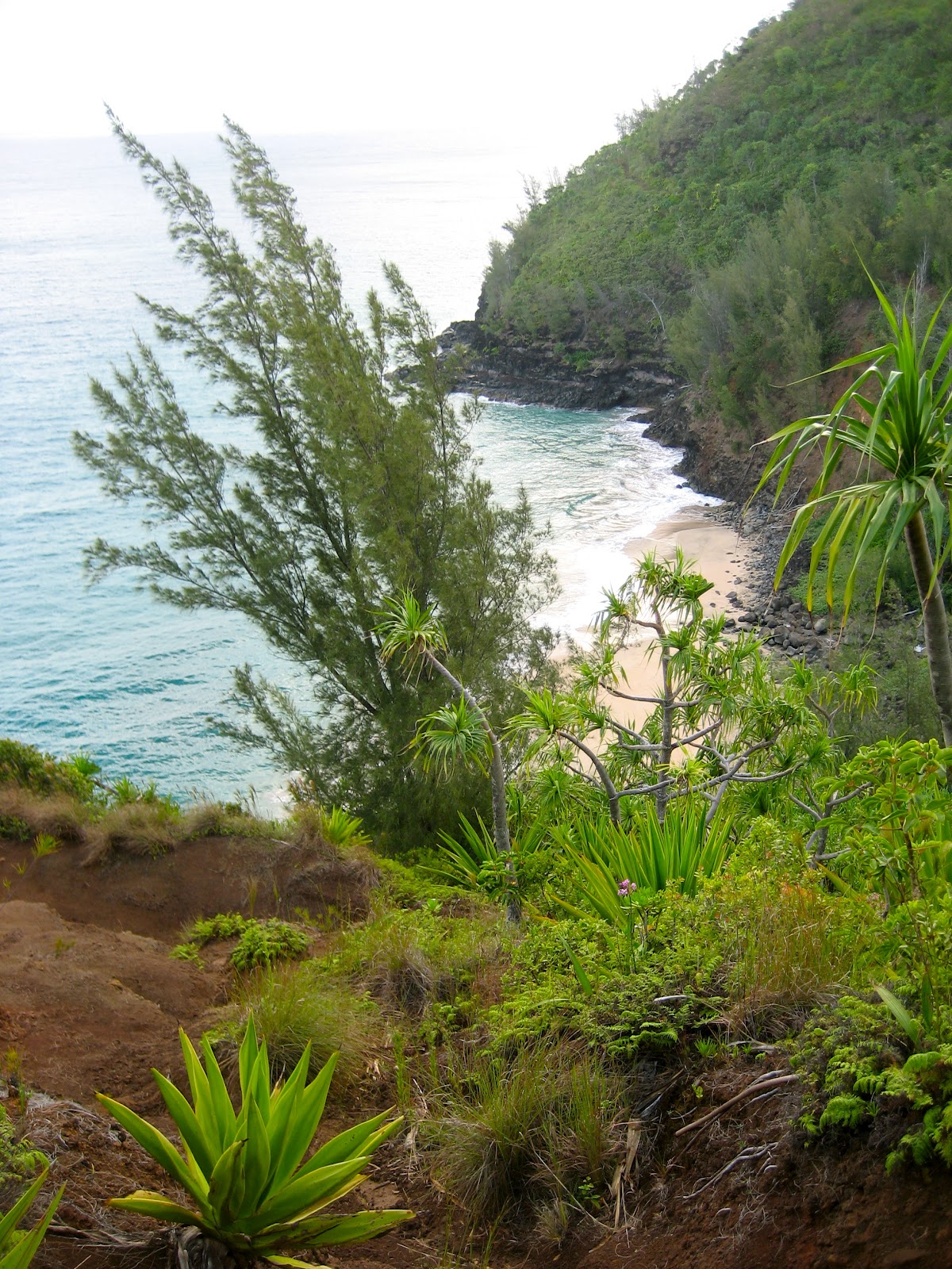
 Despite lots of rain the previous week, the trail was completely dry and the first 2 miles to Hanakapiai was a breeze, arriving at the beach in 40 minutes.

This is as far as 99% of the tourists would go. From here, the trail gets considerably more technical and prone to turning to a muddy trough after each rain shower. I was very lucky, few drops here and there, but weather stayed mostly dry. So I jogged wherever the surface and my lungs allowed and tried to use my brain to think about three steps ahead on wet rocky sections. Traction of my shoes was near perfect on all but the slickest rocks, but after a while, I got used to slight sliding of soles on rocks upon each step. I arrived at the camp at mile 6 in Hanakoa Valley after another two hours, soaked with sweat but with dry feet. Here, instead of continuing for another mile or two, I decided to search for a side trail leading to Hanakoa Falls. After two unsuccessful attempts of hiking up overgrown stream beds to impenetrable jungle, and asking passing hikers (blank stares...), I finally identified the trail using a trail map picture I took at the start.
 This half mile trail followed a stream pretty much all the way to kind of an anemic waterfall (9/5 update: searching the web for Hanakoa Falls pictures I found that the waterfall I reached indeed was not the 1000 ft high Hanakoa, so it means I got lost somewhere along the way):
 The search for trails and waterfall hike took me an hour and my shoes and socks were completely soaked by now. So for crossing the Hanakoa stream on the way back, I put the neoprene socks on. Good idea, as I got going, it started to pour and heavy rain came in sheets. I took this lo-res video which may look like walking among your grandma's flower beds in a sprinkle...
Back at Hanakopiai beach, the weather improved, so after crossing the stream knee deep, I pushed myself to a trot, scrambled up steep switchbacks and actually ran on rocky down slopes back to Ke'e beach.

I was back at the trail head at 1:15, after 5 hours and 45 minutes and about 7 miles. So it looks like this way of traveling along the KT is the way to go, for an overnight hike I would need a hammock or a light bivy and little more food. Good grippy sole on your shoes is the most important factor, in my opinion, and the neoprene socks worked wonderfully, saving one the need of dangerous scrambling over slick rocks while crossing streams, or changing into tabis or water sandals.
The silver lining on this trip for Marketa was that we were able to convince the race officials to roll her marathon entry to 2013! That means, we will be back, and if all goes as planned... check back here in a year. The Na Pali cliffs will certainly still be there.

So we were back a year later, this time equipped with heavy duty hiking gore-tex boots, backpacks, sleeping pads and bags, a tent, stove, dried meals, camelbaks and water filters etc etc.

It rained, because it always rains in Kauai, the trail was wet, muddy, slippery, rutted, steep and rocky. It took us eleven hours to reach the Kalalau Beach, so the pace was 1mph. The beach at the trail's end was worth all the effort.

It rained some more on our way back the next day and I remember being pretty desperate about my wet boots, socks and blistered feet. Water got inside my boots not from walking through the mud puddles, but from the top, flowing alongside my legs in rain and every time I dragged my legs through wet vegetation. It was a tough hike. We realized we overpacked a lot and decided that one day, we will be back one day for a fast, minimalist overnight hike.
That day almost happened to be this past weekend. I say almost, because the original plan was quite different: Marketa flew to Kauai to run her third Kauai marathon (and her third this year). But a plane-acquired virus got a hold of her and her taper leisure 5 mile run a week before the marathon weekend ended up in projectile vomiting all over the lush island vegetation. Next, she ended up in bed with a high fever. So I packed all light hiking accessories and went to Kauai hoping that if running a marathon was out of question, the Kalalau trail would be an easier substitute when she got a bit better. By Saturday, it was clear that the virus was a vicious one and plans had to be modified again. We decided on me testing the light hike version and gear by allowing myself about seven hours for the hike and to see how far I would get in 3.5 hours before turning back.
Despite wearing the same T-shirt and shorts as eight years ago (yes, the Patagonia gear is indestructible), I carried a Camelbak with 3 liters, a filter, first aid kit, an emergency headlight, and three power bars. Most importantly, I had put on my trail running Adidas shoes, running socks, and insulated my feet with waterproof gaiters. I also carries spare socks in a ziplock bag as well as thin neoprene socks.


This is as far as 99% of the tourists would go. From here, the trail gets considerably more technical and prone to turning to a muddy trough after each rain shower. I was very lucky, few drops here and there, but weather stayed mostly dry. So I jogged wherever the surface and my lungs allowed and tried to use my brain to think about three steps ahead on wet rocky sections. Traction of my shoes was near perfect on all but the slickest rocks, but after a while, I got used to slight sliding of soles on rocks upon each step. I arrived at the camp at mile 6 in Hanakoa Valley after another two hours, soaked with sweat but with dry feet. Here, instead of continuing for another mile or two, I decided to search for a side trail leading to Hanakoa Falls. After two unsuccessful attempts of hiking up overgrown stream beds to impenetrable jungle, and asking passing hikers (blank stares...), I finally identified the trail using a trail map picture I took at the start.


Back at Hanakopiai beach, the weather improved, so after crossing the stream knee deep, I pushed myself to a trot, scrambled up steep switchbacks and actually ran on rocky down slopes back to Ke'e beach.
I was back at the trail head at 1:15, after 5 hours and 45 minutes and about 7 miles. So it looks like this way of traveling along the KT is the way to go, for an overnight hike I would need a hammock or a light bivy and little more food. Good grippy sole on your shoes is the most important factor, in my opinion, and the neoprene socks worked wonderfully, saving one the need of dangerous scrambling over slick rocks while crossing streams, or changing into tabis or water sandals.
The silver lining on this trip for Marketa was that we were able to convince the race officials to roll her marathon entry to 2013! That means, we will be back, and if all goes as planned... check back here in a year. The Na Pali cliffs will certainly still be there.
 |
| Na Pali coast as viewed from our helicopter flight on Monday 9/3 |

Sunday, August 26, 2012
Wednesday, August 15, 2012
Scouting out Sierra Buttes trails
Having barely survived a tough bike ride on a hot day last week, we took off for a four day camping trip in the Gold Country, with the goal of exploring trails around Downieville, Sierra Buttes and Lakes Basin. I did not bring a bike with me, Marketa and I wanted to hike and run some of the trails together.
Equipped with a detailed and indestructible tyvek map of the area, purchased at the Yuba Expeditions bike shop, we realized there were numerous 4WD dirt roads, multiuse (hike, horse, bike, quad) trails and hike / bike singletracks. The whole trail system is maintained by the Sierra Buttes Trail Stewardship. It seems that the local guys have figured out how to make all users happy on these trails in the Tahoe National forest.
Our first destination were Tamarack Lakes on Sardine Lake overlook trail. Seven miles round trip seemed easy enough to have plenty of time either to continue onto the Sierra Buttes Lookout at 8,597 ft, or for a swim in one of the lakes. Altitude, temperature in the high nineties, underestimating the amount of water needed and very loose trail surface made this hike a tiresome affair. We slogged along the steep, loose and exposed trail in a semi-dehydrated state at a snail's pace. The trail is very steep at places, the surface is never firm, mostly consisting of loose rocks of all sizes and shapes.

Tire tracks indicated it can be ridden, but my guess is as a one way downhill from Packer Saddle, and would be very technical, but the views of Sardine lakes were fantastic.
 A late day swim in Sand Pond (an old gold mining "tailings" pit, probably full of arsenic and cyanide) cooled our dusty and overheated bodies.
Reaching the watchtower at the Sierra Buttes summit had to be postponed for the next day. It was even hotter, but this time we carried 6 liters of liquids, for another hike just six miles long and about 2000 feet elevation. Trudging slowly up a jeep road from Packer Lake, we joked that such distance and elevation is what we would normally run on trails in our neighborhood, never considering it hard. Yet here it seemed very hard, mainly I think because there was never a firm footing to be found on steep grades.
 We crossed the Pacific Crest Trail and continued up. At one trail intersection, we found bunch of 4WD vehicles, ranging from pickup trucks to all decked out Toyota FJs, with their adventurous drivers sitting in camp chairs and drinking beer. But the singletrack trail turned into a boulder field, forget about riding here.
 Another stretch of a jeep road took us to the rocky summit, where steep ladders over gaps let you climb up the lookout.
 The descent felt easier and this time, there was enough time and energy left to first get an ice cold German beer at the Packer Saddle Lodge, then jump into beautiful Packer Lake, and finally take some rest at the lake shore.

The third day of hiking took us to the Lakes Basin area. We started out on a beautiful, but for biking, very technical Grassy Lake trail along lovely waterfalls and reached Long Lake, a real jewel.


As during the previous couple of days, we did not see any mountain bikers on these trails and very few hikers. I saw some tire tracks on Long lake Connector trail, meaning it is rideable, but in my assessment and knowing my skills, I could imagine this would be a slow, technical and unforgiving ride, with lots of rocky drops and a constant lifting of the front wheel over obstacles.

Our planned afternoon of swimming in Long Lake was rudely interrupted by a sudden thunderstorm, which had formed within minutes from a few innocently looking cumulus clouds.

Since the weather forced us off the mountains early, we had plenty of time to stop in Davis on the way home, to enjoy some tasty Czech food and wine in Little Prague restaurant despite the evening 100F temperature.
In conclusion, it seems that trails marked as green dashed lines on the Yuba Expeditions map are much more suitable for mountain biking, the red marked trails are super technical and would likely include lots of hike a bike. Using the shuttle service from Downieville to Packer Saddle and riding the famous Butcher Ranch, Pauley Creek and Divide trails back to town is probably the best option to taste these trails. Numerous other rides are surely possible by combining the jeep roads and singletracks, although none would be very easy, that I am sure of. The whole area is very scenic and not very populated, making it a paradise for outdoor sports, as the few who live here must have discovered.
Equipped with a detailed and indestructible tyvek map of the area, purchased at the Yuba Expeditions bike shop, we realized there were numerous 4WD dirt roads, multiuse (hike, horse, bike, quad) trails and hike / bike singletracks. The whole trail system is maintained by the Sierra Buttes Trail Stewardship. It seems that the local guys have figured out how to make all users happy on these trails in the Tahoe National forest.
Our first destination were Tamarack Lakes on Sardine Lake overlook trail. Seven miles round trip seemed easy enough to have plenty of time either to continue onto the Sierra Buttes Lookout at 8,597 ft, or for a swim in one of the lakes. Altitude, temperature in the high nineties, underestimating the amount of water needed and very loose trail surface made this hike a tiresome affair. We slogged along the steep, loose and exposed trail in a semi-dehydrated state at a snail's pace. The trail is very steep at places, the surface is never firm, mostly consisting of loose rocks of all sizes and shapes.

Tire tracks indicated it can be ridden, but my guess is as a one way downhill from Packer Saddle, and would be very technical, but the views of Sardine lakes were fantastic.

Reaching the watchtower at the Sierra Buttes summit had to be postponed for the next day. It was even hotter, but this time we carried 6 liters of liquids, for another hike just six miles long and about 2000 feet elevation. Trudging slowly up a jeep road from Packer Lake, we joked that such distance and elevation is what we would normally run on trails in our neighborhood, never considering it hard. Yet here it seemed very hard, mainly I think because there was never a firm footing to be found on steep grades.


The third day of hiking took us to the Lakes Basin area. We started out on a beautiful, but for biking, very technical Grassy Lake trail along lovely waterfalls and reached Long Lake, a real jewel.


As during the previous couple of days, we did not see any mountain bikers on these trails and very few hikers. I saw some tire tracks on Long lake Connector trail, meaning it is rideable, but in my assessment and knowing my skills, I could imagine this would be a slow, technical and unforgiving ride, with lots of rocky drops and a constant lifting of the front wheel over obstacles.

Our planned afternoon of swimming in Long Lake was rudely interrupted by a sudden thunderstorm, which had formed within minutes from a few innocently looking cumulus clouds.

Since the weather forced us off the mountains early, we had plenty of time to stop in Davis on the way home, to enjoy some tasty Czech food and wine in Little Prague restaurant despite the evening 100F temperature.
In conclusion, it seems that trails marked as green dashed lines on the Yuba Expeditions map are much more suitable for mountain biking, the red marked trails are super technical and would likely include lots of hike a bike. Using the shuttle service from Downieville to Packer Saddle and riding the famous Butcher Ranch, Pauley Creek and Divide trails back to town is probably the best option to taste these trails. Numerous other rides are surely possible by combining the jeep roads and singletracks, although none would be very easy, that I am sure of. The whole area is very scenic and not very populated, making it a paradise for outdoor sports, as the few who live here must have discovered.
Friday, August 3, 2012
Hear, hear!
I don't demand attention by this post (would that be Blog, blog!)? I want to touch upon the topic of hearing well and listening to music while biking or running. On a bike, at least on roads, I would never plug my ears with earphones blasting loud music. This works great on a stationary trainer, but could be rather deadly on the road. Actually, it is increasingly dangerous for me to ride even with my ears unplugged. The reason for me hearing approaching cars at the last second is a hereditary hearing loss. Until recently, I have been using a sophisticated hearing aid of the so called open fit / behind the ear design. It works great at work, but due to the microphone location on the main device body, which is positioned behind your ear lobe, it is very sensitive to wind noise. Forget about wearing it on your bike. There are custom fitted hearing aids that sit in your ear canal but so far, these have been very expensive. For the last couple of weeks, I have been trying a new product by Starkey Laboratories, called AMP. These hearing aids are programmable for mild to moderate hearing loss and come in three sizes to fit your ears.

and a nice case with the magnetic wand, used to control the settings, included.

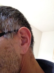
Since sound is delivered naturally through your ear lobe and canal, wind noise is not over-amplified. I tried my new bionic ears in one 40 mile road ride and they worked great: every approaching car scared the hell out of me, all of a sudden I heard every little creak of my cranks and pedals, and every shift made me almost jump off my bike. Sweating and moving my jaw when drinking did not loosen the fit and the AMPs stay where they are supposed to. Plus the benefit is that they are almost invisible off the bike.

Now as far as running goes, I would not mind tuning the whole world out and listen to a good rhythm. Many runners do, and of course, this drives us bicyclists crazy when we pass them, yelling "on your left!" to no avail. In running, my problem has not been hearing well, but rather keeping the earphones in my ears. Every type and brand I tried so far would fall out after a short time, including the plug types. During a recent visit to REI, I filled out a sweepstakes entry form and I won! A pair of Yurbuds. They sure look cool with the red Mylar cord but esthetics don't matter much if you end up with your buds dangling over your shoulders after a quarter mile on trails. The Twist Lock shells claim to stay in your ears while jumping off rocks during a category 7 earthquake, and so far they passed the stairs-jumping test at home. A trail report will hopefully follow soon, as soon as my quads recover from the pavement induced beating of the San Francisco half marathon.

and a nice case with the magnetic wand, used to control the settings, included.

Since sound is delivered naturally through your ear lobe and canal, wind noise is not over-amplified. I tried my new bionic ears in one 40 mile road ride and they worked great: every approaching car scared the hell out of me, all of a sudden I heard every little creak of my cranks and pedals, and every shift made me almost jump off my bike. Sweating and moving my jaw when drinking did not loosen the fit and the AMPs stay where they are supposed to. Plus the benefit is that they are almost invisible off the bike.
Now as far as running goes, I would not mind tuning the whole world out and listen to a good rhythm. Many runners do, and of course, this drives us bicyclists crazy when we pass them, yelling "on your left!" to no avail. In running, my problem has not been hearing well, but rather keeping the earphones in my ears. Every type and brand I tried so far would fall out after a short time, including the plug types. During a recent visit to REI, I filled out a sweepstakes entry form and I won! A pair of Yurbuds. They sure look cool with the red Mylar cord but esthetics don't matter much if you end up with your buds dangling over your shoulders after a quarter mile on trails. The Twist Lock shells claim to stay in your ears while jumping off rocks during a category 7 earthquake, and so far they passed the stairs-jumping test at home. A trail report will hopefully follow soon, as soon as my quads recover from the pavement induced beating of the San Francisco half marathon.

Subscribe to:
Posts (Atom)